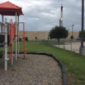
FRACKING AND ARLINGTON'S SCHOOLCHILDREN
IN THIS PAGE
Click on any section title to jump directly to that section
A Data Sheet listing all fracking sites and gas wells for each Arlington Independent School District (AISD) school, in alphabetical order.
Data-driven patterns found from analyzing fracking near Arlington schools.
Report from CHPNY outlining the current and potential public health repercussions of Arlington's fracking on schoolchildren.
Map from the FracTracker Alliance to help visualize drilling around Arlington's schools
FRACKING SITES AND GAS WELLS NEAR EVERY ARLINGTON PUBLIC SCHOOL
WHAT'S SHOWN?
For each AISD school, we provide a list of all nearby drill sites, as well as information about the number of nearby gas wells. We list AISD elementary schools first, then AISD junior high schools, then AISD high schools, in alphabetical order.
LEGEND
Drill Site Listings Format
DRILL SITE BETWEEN 0-0.5 miles
DRILL SITE BETWEEN 0.5-1 mile
DRILL SITE BETWEEN 1-2 miles
Well Count Tracker Format
93
26
26
Number of gas wells between 1-2 mi
Number of gas wells between 0.5-1 mi
Number of gas wells between 0-0.5 mi
Data Sources:
Gas wells: FracTracker, Drill sites: FracTracker & City of Arlington
School locations: AISD, Enrollment: TEA
AISD Elementary Schools
LONESTAR (0.08 Miles)
MAVERICK (0.37 Miles)
AC 360 (0.42 Miles)
RICE LOH (0.47 Miles)
ARKANSAS (0.77 Miles)
AGAPE (0.95 Miles)
MATLOCK (1.32 Miles)
GALLETTA (1.37 Miles)
HIGHPOINT (1.44 Miles)
TRADER'S VILLAGE (1.7 Miles)
UPPER (1.94 Miles)
AIRFIELD (1.99 Miles)
Total Wells=120
63
16
41
GALLETTA (0.66 Miles)
MATLOCK (0.66 Miles)
RICE LOH (0.80 Miles)
AGAPE (1.04 Miles)
HIGHPOINT (1.19 Miles)
STONER (1.21 Miles)
O'DAY (1.36 Miles)
LONESTAR (1.41 Miles)
PERR (1.49 Miles)
LANDING (1.59 Miles)
ROCKING HORSE (1.69 Miles)
MAVERICK (1.71 Miles)
AC 360 (1.76 Miles)
Total Wells=140
117
23
0
UPPR (0.71 Miles)
AC 360 (0.82 Miles)
MAVERICK (0.86 Miles)
ARKANSAS (0.93 Miles)
LONESTAR (1.17 Miles)
GM (1.26 Miles)
SW PARKWAY (1.72 Miles)
Total Wells=91
39
52
0
EDEN SW (0.43 Miles)
MANSFIELD WELLS (0.57 Miles)
CORNERSTONE (1.16 Miles)
DUKE (1.18 Miles)
SUE BARNETT (1.32 Miles)
MATLOCK THORNTON (1.37 Miles)
DEBBIE LANE (1.84 Miles)
Total Wells=95
70
7
18
AGAPE (0.29 Miles)
MATLOCK (0.64 Miles)
RICE LOH (0.68 Miles)
HIGHPOINT (0.76 Miles)
LONESTAR (0.85 Miles)
ARKANSAS (1.08 Miles)
MAVERICK (1.11 Miles)
AC 360 (1.19 Miles)
GALLETTA (1.31 Miles)
TRADERS VILLAGE (1.36 Miles)
I-20 JV (1.64 Miles)
ARFIELD (1.84 Miles)
Total Wells=112
62
43
7
CORNERSTONE (0.44 Miles)
EDEN SW (0.90 Miles)
MATLOCK THORNTON (1.07 Miles)
LANDING (1.16 Miles)
ROCKING HORSE (1.27 Miles)
MANSFIELD WELLS (1.30 Miles)
PALOS VERDES (1.44 Miles)
SUE BARNETT (1.45 Miles)
DUKE (1.48 Miles)
STONER (1.61 Miles)
Total Wells=139
110
18
11
SUE BARNETT (0.12 Miles)
FULSON (0.97 Miles)
MANSFIELD WELLS (1.07 Miles)
LYNN (1.15 Miles)
ROCKING HORSE (1.56 Miles)
EDEN SW (1.67 Miles)
I-20 JV (1.73 Miles)
CROSSROAD (1.73 Miles)
SUNBELT (1.87 Miles)
Total Wells=116
92
15
9
GM (0.67 Miles)
TRUMAN (0.94 Miles)
AC 360 (1.11 Miles)
MAVERICK (1.20 Miles)
LONESTAR (1.28 Miles)
RICE LOH (1.35 Miles)
UTS (1.48 Miles)
UPPR (1.54 Miles)
GALLETTA (1.73 Miles)
Total Wells=123
93
10
20
GALLETTA (0.47 Miles)
RICE LOH (0.84 Miles)
UTS (0.85 Miles)
O'DAY (1.44 Miles)
LONESTAR (1.45 Miles)
PERR (1.49 Miles)
TRUMAN (1.55 Miles)
MAVERICK (1.65 Miles)
AC 360 (1.65 Miles)
Total Wells=98
59
37
2
FULSON (0.33 Miles)
SUE BARNETT (0.68 Miles)
I-20 JV (0.74 Miles)
ROCKING HORSE (1.06 Miles)
LYNN (1.33 Miles)
HIGHPOINT (1.62 Miles)
LANDING (1.75 Miles)
Total Wells=95
53
27
15
O'DAY (0.63 Miles)
GALLETTA (0.66 Miles)
PERR (0.77 Miles)
STONER (0.99 Miles)
MATLOCK (1.15 Miles)
RICE LOH (1.33 Miles)
LANDING (1.40 Miles)
AGAPE (1.66 Miles)
HIGHPOINT (1.70 Miles)
ROCKING HORSE (1.74 Miles)
Total Wells=112
72
40
0
MARTIN (0.45 Miles)
ROLLING HILLS (0.52 Miles)
GREENMAN (0.95 Miles)
VILLAGE CREEK WEST (1.47 Miles)
Total Wells=45
26
17
2
KISD (0.92 Miles)
BRUDER (0.93 Miles)
SWAPO II (0.94 Miles)
LENOX (1.56 Miles)
BOGI (1.89 Miles)
Total Wells=90
41
49
0
UPPR (0.30 Miles)
GM (1.03 Miles)
AC360 (1.04 Miles)
MAVERICK (1.13 Miles)
ARKANSAS (1.43 Miles)
LONESTAR (1.46 Miles)
SW PARKWAY (1.76 Miles)
Total Wells=91
65
0
26
TRUMAN (0.83 Miles)
UTS (1.00 Miles)
GM (1.05 Miles)
RICE LOH (1.19 Miles)
AC 360 (1.29 Miles)
LONESTAR (1.33 Miles)
MAVERICK (1.35 Miles)
GALLETTA (1.42 Miles)
Total Wells=97
63
34
0
LABC (0.34 Miles)
LAKE ARLINGTON (1.17 Miles)
LENOX (1.17 Miles)
OLCOTT SOUTH (1.53 Miles)
OLCOTT NORTH (1.67 Miles)
STEEPLES (1.68 Miles)
BRUDER (1.74 Miles)
LAWHON WEST (1.79 Miles)
EXELON SOUTH (1.92 Miles)
BLAIR EAST (1.93 Miles)
ELKINS (1.94 Miles)
Total Wells=167
149
0
18
PANTEGO (0.85 Miles)
CH ENTERPRISE (1.25 Miles)
ELKINS (1.33 Miles)
NORTH SOWELL (1.64 Miles)
LAKE ARLINGTON (1.68 Miles)
BIG DADDY (1.79 Miles)
BOSWELL (1.94 Miles)
Total Wells=109
91
18
0
LAKE ARLINGTON (0.58 Miles)
LABC (0.78 Miles)
ELKINS (1.00 Miles)
BOSWELL (1.52 Miles)
PANTEGO (1.53 Miles)
BIG DADDY (1.63 Miles)
BOSWELL (1.67 Miles)
Total Wells=141
102
39
0
MAHARISHI (1.16 Miles)
COBRA (1.48 Miles)
HOWLING HOUND (1.73 Miles)
Total Wells=39
39
0
0
TRADERS VILLAGE (0.19 Miles)
AIRFIELD (0.66 Miles)
AGAPE (0.97 Miles)
HIGHPOINT (1.07 Miles)
ARKANSAS (1.35 Miles)
CHILDS KELLY (1.61 Miles)
MATLOCK (1.62 Miles)
I-20 JV (1.62 Miles)
LONESTAR (1.80 Miles)
MAVERICK (1.89 Miles)
CAMPBELL (1.95 Miles)
AC 360 (1.99 Miles)
Total Wells=135
108
17
10
ROCKING HORSE (0.42 Miles)
I-20 JV (0.60 Miles)
FULSON (0.96 Miles)
SUE BARNETT (0.99 Miles)
LANDING (1.13 Miles)
STONER (1.35 Miles)
HIGHPOINT (1.37 Miles)
MATLOCK (1.50 Miles)
CORNERSTONE (1.59 Miles)
Total Wells=112
62
42
18
O'DAY (0.55 Miles)
PERR (0.63 Miles)
STONER (1.23 Miles)
LANDING (1.45 Miles)
PALOS VERDES (1.51 Miles)
GALLETTA (1.64 Miles)
Total Wells=99
77
22
0
RICE LOH (0.34 Miles)
GALLETTA (0.50 Miles)
MATLOCK (0.98 Miles)
LONESTAR (1.00 Miles)
AGAPE (1.03 Miles)
MAVERICK (1.29 Miles)
AC 360 (1.33 Miles)
HIGHPOINT (1.37 Miles)
O'DAY (1.55 Miles)
ARKANSAS (1.59 Miles)
PERR (1.66 Miles)
STONER (1.70 Miles)
UTS (1.87 Miles)
Total Wells=135
101
19
15
AGAPE (0.11 Miles)
HIGHPOINT (0.37 Miles)
MATLOCK (0.72 Miles)
TRADERS VILLAGE (0.85 Miles)
ARKANSAS (1.10 Miles)
LONESTAR (1.18 Miles)
RICE LOH (1.20 Miles)
I-20 JV (1.22 Miles)
AIRFIELD (1.37)
MAVERICK (1.38 Miles)
AC 360 (1.47 Miles)
ROCKING HORSE (1.76 Miles)
Total Wells=123
92
18
13
PANTEGO (0.53 Miles)
PERR (1.24 Miles)
ELKINS (1.28 Miles)
O'DAY (1.33 Miles)
CH ENTERPRISE (1.38 Miles)
Total Wells=45
38
7
0
LONESTAR (0.19 Miles)
MAVERICK (0.28 Miles)
AC 360 (0.28 Miles)
RICE LOH (0.56 Miles)
ARKANSAS (0.87 Miles)
GALLETTA (1.40 Miles)
AGAPE (1.43 Miles)
GM (1.63 Miles)
UPPER (1.64 Miles)
MATLOCK (1.79 Miles)
TRADERS VILLAGE (1.98)
Total Wells=123
73
22
28
ROLLING HILLS (0.17 Miles)
MARTIN (0.76 Miles)
TRUMAN (1.45 Miles)
GREENMAN (1.58 Miles)
Total Wells=67
35
17
15
BRUDER (0.97 Miles)
ELKINS (1.23 Miles)
PANTEGO (1.72 Miles)
O'DAY (1.81 Miles)
PERR (1.83 Miles)
LABC (1.87 Miles)
Total Wells=83
57
26
0
TRUMAN (0.28 Miles)
ROLLING HILLS (1.13 Miles)
UTS (1.13 Miles)
GM (1.62 Miles)
CH ENTERPRISE (1.81 Miles)
Total Wells=94
74
10
10
COBRA (0.24 Miles)
MAHARISHI (1.13 Miles)
APPALOOSA (1.19 Miles)
SW PARKWAY (1.21 Miles)
DLS-QUARTER HORSE (1.76 Miles)
Total Wells
44
0
16
LABC (0.53 Miles)
LENOX (0.81 Miles)
BRUDER (1.23 Miles)
STEEPLES (1.51 Miles)
SWAPO II (1.66 Miles)
LAKE ARLINGTON (1.81 Miles)
OLCOTT SOUTH (1.95 Miles)
Total Wells
83
47
0
STONER (0.54 Miles)
MATLOCK (0.69 Miles)
LANDING (0.96 Miles)
O'DAY (0.96 Miles)
GALLETTA (0.99 Miles)
PERR (1.13 Miles)
ROCKING HORSE (1.18 Miles)
HIGHPOINT (1.21 Miles)
AGAPE (1.28 Miles)
RICE LOH (1.36 Miles)
I-20 JV (1.56 Miles)
Total Wells
70
55
0
LENOX (0.20 Miles)
STEEPLES (0.46 Miles)
YEANDLE (0.99 Miles)
OLCOTT SOUTH (1.22 Miles)
LABC (1.44 Miles)
CASE PRICKETT (1.44 Miles)
LAWHON WEST (1.52 Miles)
SWAPO II (1.56 Miles)
OLCOTT NORTH (1.59 Miles)
DUKE (1.63 Miles)
WHIZ EAST (1.65 Miles)
LAWHON SOUTH (1.71 Miles)
MARTIN FOREST HILLS (1.76 Miles)
Total Wells=214
144
19
51
KISD (1.07 Miles)
BRUDER (1.17 Miles)
SWAPO II (1.29 Miles)
FANNIN FARMS (1.63 Miles)
PALOS VERDES (1.78 Miles)
BOGI (1.88 Miles)
Total Wells=115
115
0
0
GALLETTA (0.43 Miles)
O'DAY (0.72 Miles)
PERR (0.84 Miles)
RICE LOH (1.20 Miles)
STONER (1.22 Miles)
MATLOCK (1.28 Miles)
LANDING (1.64 Miles)
AGAPE (1.70 Miles)
UTS (1.94 Miles)
Total Wells=107
84
21
2
UPPR (0.37 Miles)
GM (1.18 Miles)
AC 360 (1.22 Miles)
MAVERICK (1.29 Miles)
ARKANSAS (1.47 Miles)
LONESTAR (1.63 Miles)
SW PARKWAY (1.67 Miles)
Total Wells=145
93
26
26
MAHARISHI (1.23 Miles)
ROLLING HILLS (1.24 Miles)
MARTIN (1.51 Miles)
GM (1.58 Miles)
TRUMAN (1.64 Miles)
Total Wells=55
55
0
0
MANSFIELD WELLS (0.19 Miles)
EDEN SW (0.50 Miles)
DUKE (1.13 Miles)
DEBBIE LANE (1.18 Miles)
SUE BARNETT (1.55 Miles)
DAY (1.71 Miles)
MATLOCK THORNTON (1.72 Miles)
CORNERSTONE (1.74 Miles)
SUNBELT (1.87 Miles)
Total Wells=119
94
0
25
CH ENTERPRISE (0.60 Miles)
BALLARD (1.28 Miles)
NORTH SOWELL (1.36 Miles)
DUNN (1.54 Miles)
GREENMAN (1.60 Miles)
CLANECO (1.96 Miles)
4 PLUGGED SITES
Total Wells=47
41
6
0
RICE LOH (0.35 Miles)
LONESTAR (0.67 Miles)
MAVERICK (0.85 Miles)
AC 360 (0.85 Miles)
GALLETTA (0.89 Miles)
ARKANSAS (1.39 Miles)
AGAPE (1.53 Miles)
UTS (1.53 Miles)
TRUMAN (1.71 Miles)
GM (1.71 Miles)
MATLOCK (1.72 Miles)
Total Wells=121
78
30
13
AIRFIELD (0.88 Miles)
ARKANSAS (1.06 Miles)
CHILDS KELLY (1.19 Miles)
TRADERS VILLAGE (1.28 Miles)
MAVERICK (1.72 Miles)
AC 360 (1.78 Miles)
LONESTAR (1.90 Miles)
CAMPBELL (1.99 Miles)
Total Wells=65
65
6
0
MARTIN (0.35 Miles)
HOWLING HOUND (1.07 Miles)
ROLLING HILLS (1.19 Miles)
GREENMAN (1.57 Miles)
SURBER (1.63 Miles)
JW ARLINGTON (1.70 Miles)
BASS ARLINGTON (1.77 Miles)
KNAPP (1.77 Miles)
REGAN ARLINGTON (1.80 Miles)
ULESS (1.86 Miles)
CWS COMMUNITIES (1.88 Miles)
VILLAGE CREEK WEST (1.91 Miles)
Total Wells=112
108
2
2
PERR (0.86 Miles)
O'DAY (0.90 Miles)
PANTEGO (1.02 Miles)
ELKINS (1.14 Miles)
BRUDER (1.75 Miles)
Total Wells=65
44
21
0
PERR (0.86 Miles)
O'DAY (0.95 Miles)
GALLETTA (1.06 Miles)
UTS (1.24 Miles)
PANTEGO (1.57 Miles)
CH ENTERPRISE (1.70 Miles)
Total Wells=60
39
21
0
ROLLING HILLS (0.78 Miles)
TRUMAN (0.88 Miles)
CH ENTERPRISE (1.35 Miles)
UTS (1.55 Miles)
MARTIN (1.80 Miles)
Total Wells=57
32
25
0
WC TOLLWAY (1.03 Miles)
FULSON (1.18 Miles)
I-20 JV (1.45 Miles)
CAMPBELL (1.86 Miles)
LYNN (1.89 Miles)
TRADERS VILLAGE (1.98 Miles)
HIGHPOINT (1.99 Miles)
Total Wells=67
67
0
0
ROLLING HILLS (0.78 Miles)
TRUMAN (0.88 Miles)
UTS (1.34 Miles)
PANTEGO (1.34 Miles)
CH ENTERPRISE (1.35 Miles)
MARTIN (1.80 Miles)
Total Wells=64
39
25
0
AC 360 (0.27 Miles)
MAVERICK (0.39 Miles)
LONESTAR (0.60 Miles)
ARKANSAS (0.98 Miles)
RICE LOH (1.06 Miles)
UPPR (1.12 Miles)
GM (1.13 Miles)
Total Wells=96
59
20
17
ROLLING HILLS (0.38 Miles)
TRUMAN (0.99 Miles)
MARTIN (1.39 Miles)
CH ENTERPRISE (1.56 Miles)
GREENMAN (1.58 Miles)
UTS (1.94 Miles)
Total Wells=69
34
10
15
FULSON (0.69 Miles)
I-20 JV (0.85 Miles)
SUE BARNETT (1.58 Miles)
HIGHPOINT (1.62 Miles)
LYNN (1.67 Miles)
WC TOLLWAY (1.71 Miles)
ROCKINGHORSE (1.77 Miles)
Total Wells=91
58
33
0
LANDING (0.20 Miles)
CORNERSTONE (0.56 Miles)
STONER (0.59 Miles)
ROCKING HORSE (0.85 Miles)
PALOS VERDES (1.23 Miles)
MATLOCK THORNTON (1.46 Miles)
MATLOCK (1.76 Miles)
I-20 JV (1.81 Miles)
Total Wells=108
47
46
15
CH ENTERPRISE (0.84 Miles)
ROLLING HILLS (1.12 Miles)
GREENMAN (1.46 Miles)
TRUMAN (1.62 Miles)
BALLARD (1.82)
Total Wells=66
60
6
0
BRUDER (0.44 Miles)
PALOS VERDES (1.49 Miles)
KISD (1.76 Miles)
Total Wells=43
17
0
26
AISD Junior High Schools
Barnett Junior High
2101 E Sublett Rd.
Arlington, TX 76018
FULSON (0.30 Miles)
SUE BARNETT (0.31 Miles)
I-20 JV (1.04 Miles)
LYNN (1.05 Miles)
ROCKING HORSE (1.15 Miles)
MANSFIELD WELLS (1.73 Miles)
LANDING (1.78 Miles)
Total Wells=91
24
0
67
Bailey Junior High
2411 Winewood Ln.
Arlington, TX 76013
PANTEGO (0.4 Miles)
CH ENTERPRISE (1.03 Miles)
ELKINS (1.16 Miles)
PERR (1.76 Miles)
Total Wells=32
7
0
25
Gunn Junior High
3000 S Fielder Rd.
Arlington, TX 76015
PERR (0.50 Miles)
O'DAY (0.54 Miles)
PANTEGO (1.42 Miles)
ELKINS (1.61 Miles)
GALLETTA (1.69 Miles)
Total Wells=41
8
13
20
Boles Junior High
3900 S W Green Oaks Blvd.
Arlington, TX 76017
KISD (1.07 Miles)
BRUDER (1.17 Miles)
SWAPO II (1.29 Miles)
BOGI (1.87 Miles)
FANNIN FARMS (1.63 Miles)
PALOS VERDES (1.78 Miles)
Total Wells=92
0
0
92
Ousley Junior High
950 S E Pkwy.
Arlington, TX 76018
MANSFIELD WELLS (0.63 Miles)
EDEN SW (0.82 Miles)
SUE BARNETT (0.91 Miles)
CORNERSTONE (1.11 Miles)
ROCKING HORSE (1.49 Miles)
DUKE (1.57 Miles)
LANDING (1.61 Miles)
MATLOCK THORNTON (1.62 Miles)
FULSON (1.72 Miles)
Total Wells=133
0
34
99
Nichols Junior High
2201 Ascension Blvd.
Arlington, TX 76006
MAHARISHI (0.98 Miles)
ROLLING HILLS (1.58 Miles)
GM (1.64 Miles)
MARTIN (1.72 Miles)
HOWLING HOUND (1.81 Miles)
COBRA (1.95 Miles)
Total Wells=63
0
6
57
Shackleford Junior High
2000 N Fielder Rd.
Arlington, TX 76012
GREENMAN (0.33 Miles)
VILLAGE CREEK WEST (0.99 Miles)
MARTIN (1.02 Miles)
ROLLING HILLS (1.05 Miles)
BALLARD (1.43 Miles)
DUCK LAKE I (1.43 Miles)
CH ENTERPRISE (1.78 Miles)
DUCK LAKE II (1.84 Miles)
BASE (1.90 Miles)
Total Wells=89
2
26
61
Rodriguez Junior High
807 Sherry St.
Arlington, TX 76010
AC 360 (0.60 Miles)
MAVERICK (0.72 Miles)
GM (0.83 Miles)
LONESTAR (0.90 Miles)
UPPR (0.95 Miles)
RICE LOH (1.24 Miles)
ARKANSAS (1.30 Miles)
TRUMAN (1.60 Miles)
Total Wells=106
0
74
32
Young Junior High
3200 Woodside Dr.
Arlington, TX 76016
LABC (0.21 Miles)
BRUDER (1.03 Miles)
ELKINS (1.07 Miles)
LAKE ARLINGTON (1.37 Miles)
LENOX (1.64 Miles)
PANTEGO (1.88 Miles)
Total Wells=105
18
0
87
Workman Junior High
701 E Arbrook Blvd.
Arlington, TX 76014
STONER (0.54 Miles)
MATLOCK (0.69 Miles)
LANDING (0.96 Miles)
O'DAY (0.96 Miles)
GALLETTA (0.99 Miles)
PERR (1.13 Miles)
ROCKING HORSE (1.18 Miles)
HIGHPOINT (1.21 Miles)
AGAPE (1.28 Miles)
RICE LOH (1.36 Miles)
I-20 JV (1.56 Miles)
Total Wells=125
0
55
70
AISD High Schools
Arlington Career and College High
4900 W Arkansas Ln.
Arlington, TX 76016
LAKE ARLINGTON (0.52 Miles)
LABC (0.64 Miles)
BOSWELL (1.37 Miles)
ELKINS (1.42 Miles)
BIG DADDY (1.64 Miles)
EXELON (1.90 Miles)
EXELON SOUTH (1.93 Miles)
Total Wells=108
0
32
66
Collegiate High
2224 Southeast Pkwy.
Arlington, TX 76018
SUE BARNETT (0.13 Miles)
FULSON (0.42 Miles)
MANSFIELD WELLS (1.26 Miles)
I-20 JV (1.55 Miles)
ROCKING HORSE (1.68 Miles)
LYNN (0.55 Miles)
CROSSROADS (1.7 Miles)
Total Wells=85
24
0
61
Arlington High
818 W Park Row Dr.
Arlington, TX 76013
UTS (0.59 Miles)
GALLETTA (1.05 Miles)
PERR (1.28 Miles)
O'DAY (1.36 Miles)
CH ENTERPRISE (1.39 Miles)
TRUMAN (1.42 Miles)
RICE LOH (1.79 Miles)
Total Wells=76
0
24
52
Agriculture Science Center
2212 Michigan Ave.
DWG, TX 76013
ELKINS (0.39 Miles)
PANTEGO (0.49 Miles)
LAKE ARLINGTON (1.59 Miles)
LABC (1.66 Miles)
Total Wells=50
18
0
32
Dan Dipert Career and Technical Center
2101 Browning Dr.
Arlington, TX 76010
RICE LOH (0.09 Miles)
LONESTAR (0.53 Miles)
MAVERICK (0.75 Miles)
AC 360 (0.76 Miles)
GALLETTA (0.77 Miles)
ARKANSAS (1.23 Miles)
AGAPE (1.29 Miles)
MATLOCK (1.45 Miles)
HIGHPOINT (1.75 Miles)
Total Wells=73
13
30
30
Bowie High
2101 Highbank Dr.
Arlington, TX 76018
I-20 JV (0.17 Miles)
ROCKING HORSE (0.63 Miles)
FULSON (0.64 Miles)
HIGHPOINT (1.05 Miles)
SUE BARNETT (1.08 Miles)
MATLOCK (1.30 Miles)
LANDING (1.37 Miles)
STONER (1.51 Miles)
AGAPE (1.51 Miles)
LYNN (1.90 Miles)
Total Wells=122
18
33
71
Cavazos Center for Visual & Performing Arts
900 E Sanford St.
Arlington, TX 76011
TRUMAN (0.07 Miles)
GM (1.19 Miles)
ROLLING HILLS (1.26 Miles)
UTS (1.13 Miles)
Total Wells=69
10
0
59
Lamar High
1400 W Lamar Blvd.
Arlington, TX 76012
ROLLING HILLS (0.57 Miles)
GREENMAN (0.75 Miles)
MARTIN (0.87 Miles)
VILLAGE CREEK WEST (1.39)
CH ENTERPRISE (1.60 Miles)
TRUMAN (1.71 Miles)
BALLARD (1.80 Miles)
DUCK LAKE (1.88 Miles)
Total Wells=90
0
19
71
Martin High
4501 W Pleasant Ridge Rd.
Arlington, TX 76016
LABC (0.29 Miles)
BRUDER (0.70 Miles)
LENOX (1.20 Miles)
LAKE ARLINGTON (1.62 Miles)
SWAPO II (1.67 Miles)
ELKINS (1.79 Miles)
Total Wells=108
18
26
64
Sam Houston High
2000 Sam Houston Dr.
Arlington, TX 76014
RICE LOH (0.24 Miles)
LONESTAR (0.39 Miles)
AGAPE (0.59 Miles)
MAVERICK (0.68 Miles)
AC 360 (0.74 Miles)
ARKANSAS (0.87 Miles)
MATLOCK (0.92 Miles)
HIGHPOINT (1.08 Miles)
GALLETTA (1.11 Miles)
TRADERS VILLAGE (1.59 Miles)
AIRFIELD (1.99 Miles)
Total Wells=89
24
41
24
Seguin High
7001 Silo Rd.
Arlington, TX 76002
MANSFIELD WELLS (0.07 Miles)
EDEN SW (0.51 Miles)
SUE BARNETT (0.99 Miles)
DUKE (1.23 Miles)
CORNERSTONE (1.45 Miles)
DEBBIE LANE (1.53 Miles)
MATLOCK THORNTON (1.59 Miles)
DAY (1.72 Miles)
SUNBELT (1.94 Miles)
Total Wells=119
7
27
85
Turning Point Secondary
2209 N Davis Dr.
Arlington, TX 76012
MARTIN (0.42 Miles)
ROLLING HILLS (0.76 Miles)
GREENMAN (0.76 Miles)
VILLAGE CREEK WEST (1.26 Miles)
SURBER (1.77 Miles)
BASS ARLINGTON (1.86 Miles)
BASS (1.89 Miles)
DUCK LAKE (1.98 Miles)
Total Wells=74
2
17
55
Venture High
600 SE Green Oaks Blvd.
Arlington, TX 76018
CORNERSTONE (0.31 Miles)
LANDING (0.68 Miles)
ROCKING HORSE (0.88 Miles)
STONER (1.11 Miles)
MATLOCK THORNTON (1.19 Miles)
EDEN SW (1.27 Miles)
PALOS VERDES (1.36 Miles)
SUE BARNETT (1.45 Miles)
MANSFIELD WELLS (1.63 Miles)
I-20 JV (1.77 Miles)
DUKE (1.81 Miles)
Total Wells=157
11
33
113
SUMMARY, ANALYSIS, & FINDINGS
WHAT WE FOUND
The Impact on AISD Schools:
-
All 76 AISD schools have 3+ drill sites within 2 miles
-
69 schools have 5+ drill sites within 2 miles
-
11 schools have 50+ gas wells within 1 mile
-
44 schools have a drill site within 0.5 miles
The Impact on AISD Children:
-
53,000 AISD students are within 2 miles of 3+ drill sites
-
50,000 students are within 2 miles of 5+ drill sites
-
15,000 students are within 2 miles of 10+ drill sites
-
4,000 elementary-school children are within 0.5 miles of 25+ gas well

MAP OF ARLINGTON'S SCHOOLS AND DRILL SITES
The mapping tool below created by the Fractracker Alliance shows gas wells across Arlington, labeling the drill sites the wells belong to when possible. Most importantly, Arlington Independent School District's schools are represented as blue squares.
The map includes the locations of drill sites that host gas wells (currently existing and plugged), schools, public parks, and compressor stations in Arlington. and shows air quality data from air monitors in Arlington. You can find the number of gas wells around a location by using the Buffer Query tool, located in the menu on the top left.